Fairfield Golf Course Detention Basin Upgrade
- Project typeDetention basin
- Completion Date31 May 2023
The Fairfield Golf Course Detention Basin is one of 19 flood detention basins owned by Fairfield City Council and is located within the Fairfield Golf Course and Fairfield Showground sites.
Due to the age of the basin, mandated upgrade works were necessary to ensure:
- A higher level of flood protection to houses in the area
- Its structural integrity in large flood events
- It has functional and operational longevity into the future.
Works carried out as part of this project included:
- A full reconstruction of the existing detention basin embankment and spillway along its 940m length
- Raising the minimum embankment level
- Reconstruction of a new access road, cycleway and footpath, plus construction of 27 new car parking spaces
- Landscaping and turfing of the embankment and adjacent areas.
The project was completed in May 2023.
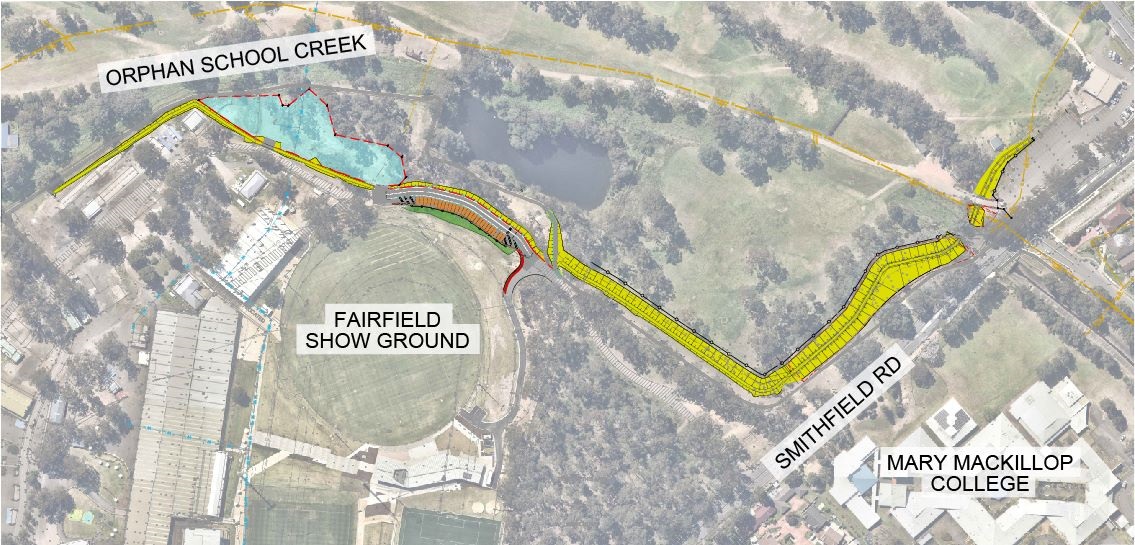
| MAP LEGEND |
| |
|
EXTENT OF WORKS |
|
|
|
ADDITIONAL CAR PARKING SPACES |
|
|
|
INFORMAL PARKING |
|
|
|
DRAINAGE |
|
|
|
LANDSCAPING |
|
|
About the Location of the Detention Basin
The detention basin stretches from Orphan School Creek, past Fairfield City Show Ground and then alongside a stretch of Smithfield Road, opposite Mary MacKillop College.
Find out more about the Fairfield Golf Course Detention Basin Upgrade here.
Location
Orphan school creek, Prairiewood 2176 View Map
-33.8685226,150.9012178
Orphan school creek ,
Prairiewood 2176
Orphan school creek ,
Prairiewood 2176
Fairfield Golf Course Detention Basin Upgrade