Fairfield City is 32km south-west of the Sydney Central Business District. It covers an area of 102 square km, incorporating 27 suburbs. Located in Western Sydney, its neighboring local government areas are Parramatta, Liverpool, Cumberland, Canterbury Bankstown, Blacktown and Penrith. Fairfield is accessible by rail, the Liverpool to Parramatta bus transitway, and the M7 motorway, which connects the M4 and M5 motorways.
We have a wide range of data about Fairfield city. This information is a great resource for community groups, investors, businesses, students. It is also available to the public and free of charge.
Follow the links below to access the data:
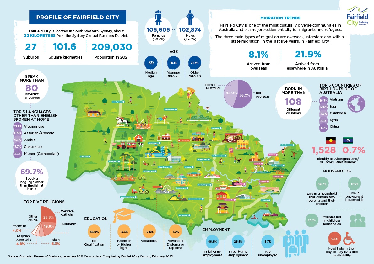
Fairfield City Profile Infographic Map 2023

Demographic Snapshot
Profile of Fairfield City
Fairfield City is located in South Western Sydney, about 32 kilometres from the Sydney Central Business District. Fairfield City has:
- 27 suburbs
- A land area of 101.6 Square kilometres
- A population of 209,030 people (as of 2021)
Population breakdown:
- 105,605 females (50.7% of the population)
- 102,874 males (49.3% of the population)
- Media age: 39
- 18.1% of the population is younger than 25
- 21.3% of the population is older than 60
Migration Trends
Fairfield City is one of the most culturally diverse communities in Australia and is a major settlement city for migrants and refugees.
The three main types of migration are overseas, interstate and within-state migration. In the last five years, in Fairfield City:
- 8.1% arrived from overseas
- 21.9% arrived from elsewhere in Australia
- 44% were born in Australia
- 56% were born overseas
Residents were born in more than 108 different countries. The top 5 countries of birth outside Australia are:
- Vietnam (16.3%)
- Iraq (12.0%)
- Cambodia (3.6%)
- Syria (2.8%)
- China (1.8%)
Residents speak more than 80 different languages. 69.7% speak a language other than English at home. The top 5 languages (other than English) spoken at home are:
- Vietnamese (21.1%)
- Assyrian/Aramaic (11.9%)
- Arabic (9.3%)
- Cantonese (3.7%)
- Khmer (Cambodian) (3.3%)
1,528 (07.% of the population) residents identify as Aboriginal and/or Torres Strait Islander.
Top five religions
- Western Catholic (26.3%)
- Buddhism (19.9%)
- Islam (6.3%)
- Assyrian Apostolic (4.8%)
- Christian (4%)
- Other (38.7%)
Education
- 58% - No qualification
- 13.3% - Bachelor or higher degree
- 12.6% - Vocational
- 7.2% Advanced Diploma or Diploma
Employment
- 46.8% in full time employment
- 26.5% are in part-time employment
- 8.7% are unemployed
Households
- 39.7%: Live in a household that contain two parents and their children
- 17.5 %: Live in one-parent households
- 17.0%: Couples live in childless households
- 9.3% need help in their day-to-day lives due to disability
Source: Australian Bureau of Statistics, based on 2021 Census data. Compiled by Fairfield City Council, February 2023.
Download the Fairfield City Profile Infographic Map here: Fairfield City Profile Infographic Map 2023(PDF, 1MB)
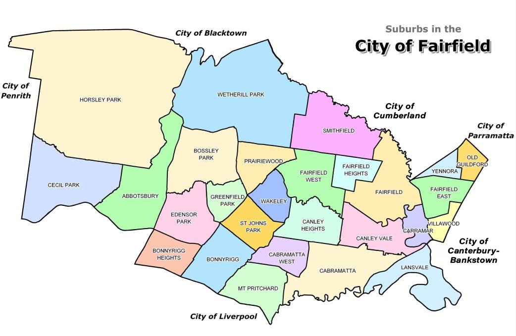
Fairfield City Council is responsible for a local government area comprised of 27 suburbs and is bordered by the Cities of Penrith, Blacktown, Cumberland (formerly Holroyd), Parramatta, Canterbury-Bankstown (formerly Bankstown) and Liverpool.

Download PDF map of the Fairfield City Suburbs(PDF, 2MB)
List of suburbs in Fairfield City
- Abbotsbury
- Bonnyrigg
- Bonnyrigg Heights
- Bossley Park
- Cabramatta
- Cabramatta West
- Canley Heights
- Canley Vale
- Carramar
- Cecil Park
- Edensor Park
- Fairfield
- Fairfield East
- Fairfield Heights
- Fairfield West
- Greenfield Park
- Horsley Park
- Lansvale
- Mt Pritchard
- Old Guildford
- Prairiewood
- St Johns Park
- Smithfield
- Villawood
- Wakeley
- Wetherill Park
- Yennora
Fairfield City is 32km south-west of the Sydney Central Business District (CBD) – about one hour's travel time. The City is easily accessible by road, rail and bus services.
By Road
Allow at least one hour if driving from Sydney's CBD.
- Take the M5 and exit at the Hume Highway, Liverpool. Turn right onto the Hume Highway, then left onto the Cumberland Highway to your destination. You can also take the Hume Highway from the CBD.
- Take the M4 and exit at South Wentworthville for the Cumberland Highway.
- From Penrith or Parramatta, drive south along the Cumberland Highway to Fairfield City.
- The Westlink M7 also provide access to Fairfield City.
By Rail
There are rail services to Fairfield City on the Bankstown, Inner West, Cumberland and South lines.
Alight at Cabramatta, Canley Vale, Fairfield, Yennora, Carramar or Villawood train stations.
Cabramatta train station is a transport interchange between CityRail services. Check times and connections with CityRail or on the Transport Infoline website or phone the Transport Infoline on 131 500.
By Bus
The T-way system provides a fast, efficient bus connection between Liverpool and Parramatta, via Fairfield City.
There are a number of stops between Bonnyrigg and Smithfield.
For timetable and fare details visit Transit Systems or phone the Transport Infoline on 131 500.
Private buses also operate within the City to connect people with education, jobs, recreation, shopping and health services.
Explore Fairfield City on Google Maps
For 30,000 years before Europeans arrived, the area now known as Fairfield City was home to the Cabrogal, an Aboriginal clan of the Darug people, whose lands were around Cabramatta Creek.
The Cabrogal ate native vegetables, grubs and animals and made bark canoes for fishing and transportation. Evidence of this period has been found in the form of scarred trees, stone tools and campsites, largely around the creeks.
Due to the rich soil of the flood plains, agriculture, farms and dairies quickly emerged. In the mid-1880s the land was used mainly for timber logging, farming and vineyards.
Fairfield is named after the family estate of John Horsley – Fairfield Manor in Somerset, England, to fhonour the family.