Cleaning up after the flood
Published on 19 February 2020

Last week, areas across Sydney including Fairfield City experienced one the worst floods in recent years.
Council has been hard at work cleaning up the mess left after this one-in-20 year flood. We have had damage to bridges and roads, and many fallen trees. Bradbury Wharf at Chipping Norton Lakes was washed downstream and we are working to make sure that it’s returned and working as soon as possible.
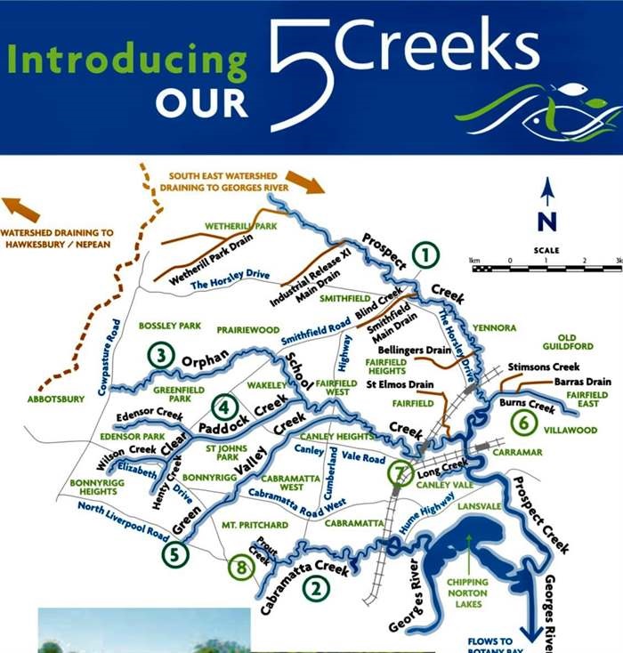
Council works hard to lessen the potential impact of storms and flooding in our City, but the reality is that floods will always happen during major weather events. Fairfield has five creeks - Prospect Creek, Orphan School Creek, Paddock Creek, Green Valley Creek and Cabramatta Creek – all located at the top of the Georges River Catchment, making our City more susceptible to floods.
These creeks collect the water from 60,000 homes, 700km of road and overland runoff. Most of this water drains into the Georges River on the way to Botany Bay. Hundreds of thousands more homes, hundreds more roads and dozens more creeks drain directly into the river downstream. Council has built detention basins that fill up during flood events to protect homes downstream, and release the water when the river empties. This system handles most rain events easily unless it becomes overwhelmed by major storm events like the one we had last week. When the Georges River fills and it reaches high tide, all creeks that drain into it stop or slow down as they rise. This stops street drains emptying into the creeks, causing flooding until the water drains from further downstream. Commonwealth and State disaster recovery assistance is available for those who have had homes, businesses or property damaged by the flood. Details on applying for assistance are available at www.disasterassist.gov.au and https://www.nsw.gov.au/resilience-nsw.

Major Creeks
| Major Creek |
Location |
| Prospect Creek |
Located at the intersection of Smithfield Road and the Horsley Drive.
Extends across Wetherill Park, Smithfield and Yennora.
|
| Cabramatta Creek |
Located in between North Liverpool Road and Hume Highway.
Extends across Mount Pritchard and Cabramatta.
|
| Orphan School Creek |
Located through Cowpasture Road, Smithfield Road and Cumberland Highway.
Extends across Abbotsbury, Greenfield Park, Wakeley, Fairfield West and Wakeley.
|
| Paddock Creek |
Extends across St Johns Park and Wakeley |
| Green Valley Creek |
Located through North Liverpool Road, Elizabeth Drive, Cabramatta Road West and Canley Vale Road.
Extends across Mount Pritchard, Bonnyrigg, Cabramatta West and Canley Heights.
|
Minor Creeks
| Minor Creek |
Location |
| Burns Creek |
Extends across Villawood and Fairfield East.
|
| Long Creek |
Located near Cabramatta Road West and Canley Vale Road.
Extends across Canley Vale.
|
| Prout Creek |
Located in Mount Pritchard.
|